Trek will honour walk campaigner
Story Tools:
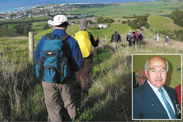
Friends and family
will take part in a trek to honour Otways walking track campaigner Les Noseda,
who died last September.
APOLLO BAY Bay residents will mark the anniversary of walking track
campaigner Les Noseda’s death by trekking one of his favourite routes.
Mr Noseda’s sister Glenda Whelan and son Andrew Noseda wanted to have a
memorial walk along Apollo Bay’s Highview Walk and they joined with the Otway
Ranges Walking Track Association to organise the event.
Mr Noseda, a founding member and former chairman of ORWTA, died on
September 15 last year.
Mrs Whelan said the memorial walk on September 9 would be a fitting
tribute to Mr Noseda.
“The Highview Walk goes up Old Tuxion Road, it gets up to Crows Nest at
the top of Tuxion, overlooking Apollo Bay,” she said.
“This was one of his favourite walks, he used to work up the top of
Tuxion at some stage and he used to run past there instead of getting in the
car to go home after work.
“I haven’t done the walk, but Les was always nagging me.”
Mrs Whelan said ORWTA members would lead the walkers along the route
from Apollo Bay’s visitor information centre from 9am and Crows Nest from 10am.
“We’re estimating we could do it very easily, the whole walk, in four
hours,” she said.
“Then we’re heading down to the hotel and having lunch.”
Donations from the walk will go to ORWTA.
The association hopes to name the trail after Mr Noseda if it can attract
enough funding to improve the track and open it to the public.
ORWTA has been campaigning for walking trails at Apollo Bay for nearly
20 years.
Association treasurer Sue McKenzie said landholders along the
11-kilometre track had given the green light for the memorial walk.
“Les helped set up the information centre years ago and he used to take
any tourists who wanted to go for a walk,” Mrs McKenzie said.
“It was his wish that the track would go ahead, it was probably one of
the few things he didn’t get to see in his lifetime but there’s a passionate
group of people who are trying to make sure that it does happen,” she said.
.JPG)
.JPG)